Should You Climb to Escape Freezing Rain While Flying IFR?
Whether or not you should depends on the situation.
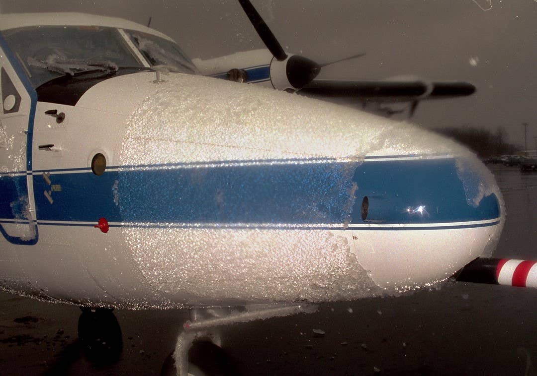
Postflight image shows ice contamination as a result of encountering supercooled large droplet (SLD) conditions near Parkersburg, West Virginia. [Credit: NASA]
If I am flying IFR and encounter freezing rain, should I climb to escape?
Answer: It’s a common misconception that you should always climb when encountering freezing rain. Most pilots are trained that freezing rain occurs when snow is falling through a cold cloud and melts completely as it encounters a temperature warmer than 0 degrees Celsius (C), turning it into rain (this is usually courtesy of a temperature inversion or what meteorologists call a warm nose). Then, those raindrops fall into a subfreezing layer below and become freezing rain (FZRA). So, in this case, there is a layer of air above that is warmer than 0 C.
- READ MORE: What Is the Best Aircraft for Time Building?
This kind of temperature profile where the precipitation begins as snow only occurs in about 8 percent of the freezing rain events according to researchers at the National Center for Atmospheric Research (NCAR). If this is what you were taught, then you were taught the exception, not the rule. Aviation meteorologists and researchers call this the “classical” freezing rain profile, where the depth of the weather can be well into flight levels. This allows for the tops to be in the favorable regime for the development of ice crystals and snow. In this case, climbing will put you in a position to at least temporarily escape the freezing rain threat. Even so, this “melting” layer may not have a sufficient depth.
Unfortunately, the real answer as to whether or not you should climb really depends on the situation. For example, climbing is usually the best option if you encounter FZRA or freezing drizzle on descent because you are your own best pilot weather report. You know that it wasn’t occurring above you, so it makes perfect sense to climb back to an altitude where you were not experiencing freezing rain.
For freezing drizzle (FZDZ), this is often not the case. There may be warmer air above you, but in some situations the temperature aloft doesn’t rise above the freezing mark. This means the entire temperature profile may be below freezing. Even if there is a layer of air warmer than 0 C, it can be very shallow in this freezing drizzle scenario.
FZDZ is normally the result of an all-liquid process as small drops in the cloud collide and coalesce into drizzle-sized drops large enough to fall out of the cloud as drizzle. So, there’s no “melting” going on here. In other words, the precipitation did not begin as snow given the top of the weather system wasn’t cold enough to be dominated by ice crystals. Instead, it is dominated by supercooled liquid water. This is what aviation meteorologists refer to as a nonclassical profile that creates FZDZ in most cases.
The best strategy in this case is to turn around and go back to the location where you were not encountering FZDZ. Once again, you are your own best pilot weather report. If you don’t know the temperature profile above you, it may not be wise to attempt a climb unless you can pop out on top of the weather into clear air. The tops of these weather systems do not usually reach into the flight levels. Nevertheless, climbing means increasing the angle of attack and placing yourself on a collision course with a stall, even for an aircraft with a certified ice protection system (IPS). Most icing accidents or incidents occur when the aircraft is operating at a high angle of attack, according to a study done by Flight Operations Research’s Steven Green.
The other fact to consider is that FZRA is largely a ground-hugging event. Most of the exposure to the classical FZRA will occur within the first two or three thousand feet of the surface. That is, it usually will be encountered while taxiing, on departure, or during arrival. It’s not something that you generally experience while flying along at cruise altitude. The nonclassical case, on the other hand, often occurs at much greater depths, sometimes as much as 16,000 feet. In those cases, you may not have the option to climb or descend to escape. It’s likely best to do a 180-degree turn and head back to a location where FZDZ was not occurring.

- READ MORE: Is Private Pilot Burnout a Real Thing?
One of the deadliest icing accidents occurred near Roselawn, Indiana, on October 31, 1994. The ATR-72-212 aircraft was on a flight from Indianapolis (KIND) to Chicago (KORD) and in a holding pattern at 10,000 feet. The flaps were extended to 15 degrees. The aircraft was in the hold for approximately 32 minutes when it was cleared to descend in the holding stack to 8,000 feet. As the flaps were retracted and the aircraft descended through 9,130 feet, the angle of attack increased beyond 5 degrees nose up. The ailerons rapidly deflected and the autopilot disconnected. The airplane rolled rapidly to the right. The aircraft was in a full right wing down position only a half of a second after the autopilot disconnected.
Following several unsuccessful attempts by the crew to correct the airplane's attitude, the aircraft crashed into a soybean field and everyone on board was killed. This was attributed to a nonclassical icing environment.
Top-Selling Aviation Gear in January
See what FLYING readers purchased for their aircraft in January 2025:


Sign-up for newsletters & special offers!
Get the latest FLYING stories & special offers delivered directly to your inbox