Bucket List: Airport in the Sky
Catalina Airport (KAVX) offers pilots a unique challenge and breathtaking views.
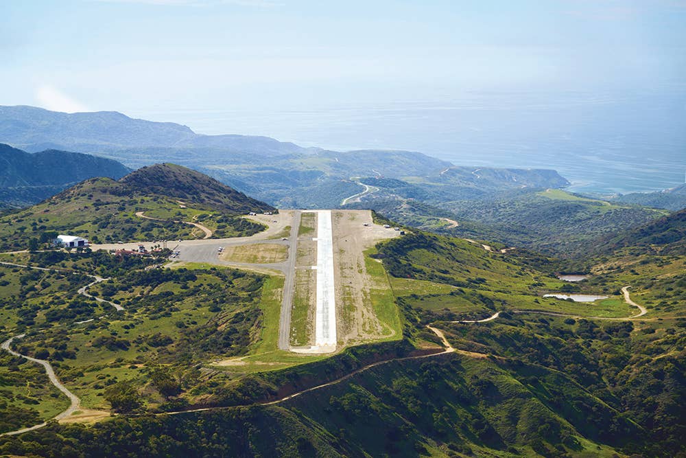
Catalina Airport (KAVX), also known as the Airport in the Sky. [Photo: Jeff Berlin]
Located 1,602 feet atop a mountain on scenic Catalina Island—offshore of Palos Verdes, California, and easily seen from the coastline of the Los Angeles basin—Catalina Airport is a bucket list destination for many pilots. Many who have been there make it a point to re-turn to enjoy the challenge of the airport and all that the area has to offer. Much like the iconic Sedona Air-port in Arizona, the ground drops off dramatically at each end of the 3,000-foot runway, making the approach challenging enough that most LA-region aircraft rental facilities require a special checkout for pilots who want to take an airplane to the island. If you’re looking for a fun challenge, Catalina is a terrific choice that also offers great attractions and delicious food.
Getting There
The first challenge of flying to KAVX lies in the approach from the mainland. As displayed on a sectional or terminal area chart, the Los Angeles basin looks much like a poorly assembled quilt filled with multiple layers of Class B, Class C, and Class D airspace, as well as a permanent TFR. While navigating this mess might be intimidating for pilots not familiar with the area, it’s just a matter of studying the chart to determine the best route and altitude to fly to stay out of the way of airspace you absolutely cannot fly through. The rest is easily handled by communicating with SoCal Approach.
If you’re coming from the north or northwest, the Los Angeles Special Flight Rules Area (SFRA) allows you to fly right over the Los Angeles International Airport (KLAX), avoiding the detour around the Class B to the east, where you would either have to fly really low (below 2,000 feet msl) or far east of downtown Los Angeles. The special flight rules instructions were easy enough to find on a paper terminal area chart, but ForeFlight and other electronic navigation services hide them well. In ForeFlight’s documents section you will find a folder named “FAA.” The folder includes all kinds of chart supplements, and in the folder named “Visual Chart Supplemental” you will find the “Los Angeles TAC Supplemental” document, which pro-vides all of the available Class B transition routes, including the Los Angeles SFRA. You need an internet connection to access these documents.
The SFRA allows pilots to fly right over the runways at KLAX while flying along the Santa Monica VOR 132 radial southeast at 3,500 feet or northwest at 4,500 feet. Per the instructions, you need to fly slower than140 kias, squawk 1201, have your anti-collision and nav lights on, and self-announce at certain locations.
While the most common transition route for light aircraft is the Los Angeles SFRA, there are other transition routes that require a Class B clearance from either SoCal Approach or Los Angeles Tower.
Arriving from the east, there are multiple layers of Class B to be aware of and a bunch of Class D and C airports, including Fullerton (KFUL), Long Beach (KLGB), Torrance (KTOA), and John Wayne/Orange County (KSNA). Also, the area around Disneyland has a permanent TFR that must be avoided. You can thread the needle between the Class B layers (as long as you stay south of the main approach segments) and the Class D and C by flying at 4,500 feet westbound. How-ever, you would be insane not to get flight following.
To provide a safety margin—in case of an engine failure over the water—you might opt to fly at 6,500 feet on the way to the island. Just be aware of the Class B segment that extends south between 5,000 and 10,000 feet near the Palos Verdes peninsula. If your intended flight path takes you through there, SoCal might provide a clearance, but make sure you hear and repeat the “cleared through Class Bravo” verbiage.
From the closest mainland point, you will only fly about 20 nm over the water. It’s close enough that you’re not required to carry life preservers, but it’s recommended to have one available for each occupant.
Other than the airport itself, the island has very few possible landing sites since its steep hills extend all the way down to the Pacific Ocean, in most areas with either very narrow strips of beach—or none at all. An engine failure will almost certainly end up in a ditching and having a life preserver could indeed save your life. Also, keep an eye out for boats since they can serve as rescue vehicles in this unlikely situation.
Landing There
Catalina Airport can get extremely busy, so it’s best to follow proper non-towered airport procedures. A point called Two Harbors—also referred to as “the isthmus”—is an easily identifiable narrowing of the island located a few miles and almost directly west of the airport. It is a perfect initial reporting point that allows you to turn onto the recommended 45-degree angle to the right downwind for Runway 22. You will likely feel really low at the 2,602-foot pattern altitude. This is an illusion courtesy of the mountain-top location, and you just have to trust your instruments (provided, of course, that you have the proper altimeter setting, which the ASOS provides). Use known power settings and the 45-degree angle to the runway as your base turn to keep a familiar descent path.
There are other illusions to overcome to avoid an incident. The NTSB database reveals a substantial list of accidents, most either near the approach or departure end of the runway. The winds favor Runway 22, which is good because Runway 4 has a 2.2 percent down slope for the last 2,300 feet. However, the slope gives the illusion of being higher than you really are. If you're low you can get stuck in downdrafts at the approach ends.
Runway 22 has a pulsating visual approach slope indicator (PVASI) with a three-degree glide slope. It is located on the left side of the runway and can be hard to see unless you know what you’re looking for. The PVASI has one light, blinking red if your approach is low; it shines solid red if you’re slightly low, solid white if you’re on the glide slope, and blinking white if you’re high. The frequency of the pulsations increases the further you get from the glide slope. The cliff drops about 1,500 feet from the airport down to the Pacific Ocean—good incentive to make it to the runway.
The upslope in the runway ends about 3/4 down the strip—a fact that has fooled many pilots. The illusion of seeing the end of the runway coming up quickly makes some pilots attempt a go around, only to have them try to stop once they see the last quarter of the runway. Those are the pilots who sometimes end up tumbling off the departure end of Runway 22. If you want to practice landings at this challenging runway, be aware that touch and gos and intersection takeoffs are prohibited.
Being There
Catalina Airport is a public-use airport. However, it is privately owned and operated by the Santa Catalina Is-land Conservancy. The first thing you need to do after you land and park in front of the Hacienda-style buildings is to run up to the office to pay the $35 landing fee. Overnight stays require an additional $20 per night.
Be aware that you might get stuck on the island unexpectedly. The weather patterns can be unpredict-able. Very low clouds can quickly shroud the airport, so keep a close eye on the marine layer. The airport has been well known for poor runway conditions. There were potholes and pebbles on the surface that made the already challenging landing a particularly bumpy affair that had potential to dam-age your airplane. In 2019, the Catalina Island Conservancy partnered with the U.S. Department of Defense to repair and restore the runway. The airport was closed for several months while about 200 Marines and Sea-bees replaced the torn pavement with concrete. While the condition of the runway is vastly improved, and you should no longer be worried about damaging your air-plane, the surface is still quite uneven.
In addition to a fun flying challenge, Catalina offers a long list of attractions. Most people hop over to the is-land for a quick buffalo burger at the DC-3 Gifts & Grill restaurant, which is mere steps from the parking area. There are other tasty items on the menu, and while the food is yummy, it is outdone by the giant cookies. By the way, the cookies are free for Catalina Aero Club members: $175 gets you unlimited landings for a year, a free cookie for every $10 you spend at the restaurant, and discounts for multiple services on the island, including the bus ride to Avalon, the main town on the island.
If you have time for a longer visit, there are lots of activities available. There is a fun and scenic hike around the entire airport. It is not uncommon to see bison roaming free (the buffalo burgers are sourced elsewhere), but beware! The bison can be aggressive and have been known to attack. If you can fit a bike into your airplane, mountain biking near the airport is also terrific. Have time to stay the night? The very scenic Little Harbor Campground sits on the east side of the island, approximately five miles from the airport. Fortunately, in this case, you hike down to the campground and up at the end of the stay, so you only have to bring your food down the hill.
If you’re looking for creature comforts, take the bus down to Avalon. It is a 10-mile venture on dirt roads, but well worth it. There are three buses that travel each way per day, so plan accordingly. Avalon has several quaint hotels and great restaurants. There are also tennis courts, a golf course, a beautiful public garden, and the iconic casino.
One visit is simply not enough for Catalina. Once you go, you will want to return.
This article appeared in the Q2 2022 issue of FLYING Magazine

Sign-up for newsletters & special offers!
Get the latest FLYING stories & special offers delivered directly to your inbox

