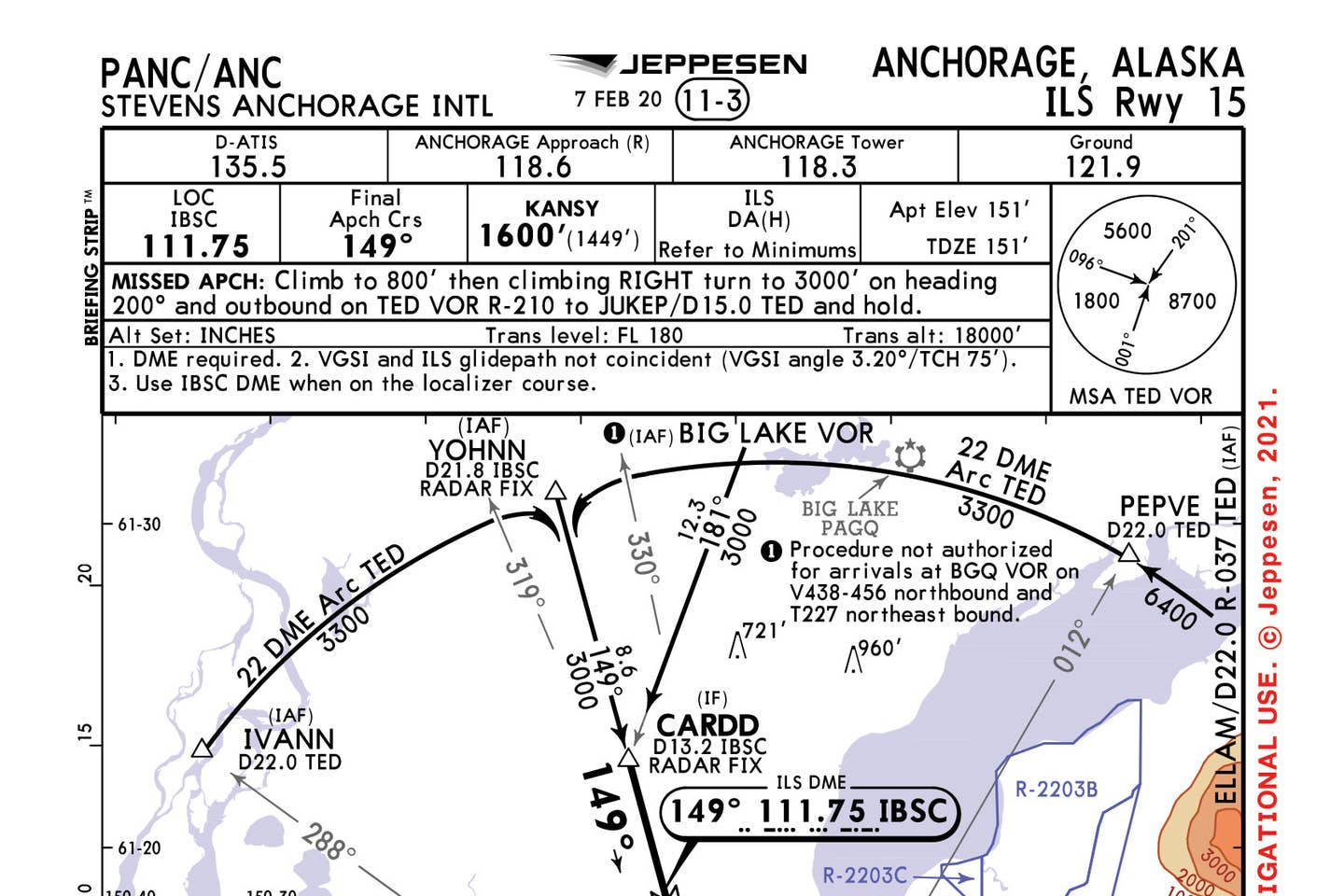
Anchorage ILS Runway 15 Courtesy Jepessen
Despite a falloff in world air traffic since early 2020, Ted Stevens Anchorage International Airport (PANC) in Alaska still represents a stopover point for thousands of airline and business-aviation flights between North America and Asia, as well as thousands of local general aviation and military airplanes. Visitors will notice that many of those local GA aircraft are mounted on floats, so they can freely move between PANC and the nearby Lake Hood Seaplane Base. About the terrain transient pilots can expect, city-data.com says: “The Chugach Mountains to the east have a general elevation of 4,000 to 5,000 feet, with peaks from 8,000 to 10,000 feet. These mountains block warm air from the Gulf of Mexico, keeping precipitation relatively low.”
A. Required Equipment
On this month’s chart, the ILS Runway 15 into PANC, pilots will learn that while many precision procedures allow a pilot to identify a final approach fix with a crossing radial, an outer marker or something similar, this procedure does not. That’s why the first note reminds pilots that DME is required. Even if an aircraft is vectored to the approach with ATC calling out the CARDD intersection, aircraft are still required to carry DME or a suitable substitute such as GPS to fly this approach.
B. DME ARC
DME arc approaches still exist, and this procedure employs two—one from each side of the final approach course. There are, however, no procedure turns. The DME arc is based on the Anchorage VOR (TED), making the arc a desirable method of establishing an aircraft on the approach. A pilot could fly directly to the TED VOR and then follow either the 288 radial to the IVANN IAF or the 012 radial to the PEPVE intersection, then via the 22-mile DME arc to intercept the IBSC localizer inbound. Pay careful attention to the requirement at some point to switch from the TED VOR to the ILS localizer that delivers DME data. It must be an easy switch to miss because Note 3 calls it out to the pilot reviewing this chart.
C. VOR to Navigate to CARDD IF
A feeder route for this approach is designated by the heavy arrow line coming from the Big Lake VOR (BGQ) to the CARDD intersection and represents a common path to join the approach from the en route environment, but there are a number of limitations. This route is not allowed “for arrivals at the BGQ VOR on V438-456 northbound and T227 northeast-bound” because it would require too steep of a turn to intercept the course back inbound.
Check out more charts: Chart Wise
D. Missed Approach or the Alternate?
Some approach plates, such as this one, publish a missed approach and an alternate missed approach procedure. Typically, these are provided when one fix may be unreliable at times—such as if a VOR is out of service—and are often located in completely different places. In this case, however, it might be easy for any pilot to be confused about why there are two, when both place the aircraft in holding at the JUKEP intersection. The primary missed approach is based around the 15-mile DME on the 210 radial from the TED VOR. The same intersection can be identified as the 34.2 DME on the 028-degree radial from the Kenai VOR (ENA). The difference here is not where an aircraft will hold but which VOR and DME source the pilot will be relying upon to establish themselves in the hold from the missed approach point.
E. No Localizer or Circling Minimums
Many ILS approaches can be flown as precision or nonprecision approaches, but this approach publishes only ILS minimums, meaning a pilot would not be able to use this approach to circle to land on another runway or if the glideslope were inoperative. It also means there is no approach timing available from the final approach fix from KANSY at the 6.2 DME point on the localizer, from the IBSC ILS transmitter.
This story appeared in the August 2021 issue of Flying Magazine

Sign-up for newsletters & special offers!
Get the latest FLYING stories & special offers delivered directly to your inbox


