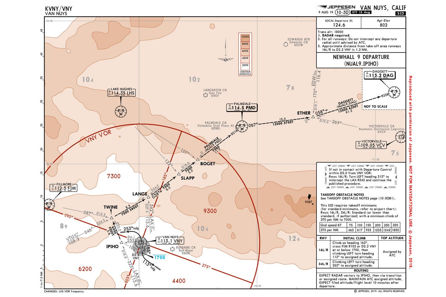
Van Nuys Newhall 9 Departure Courtesy Jeppesen
The key aspect of any standard instrument departure is the word “standard.” SIDs were created to reduce the required radio traffic between air traffic controllers and pilots, as aircraft transition from the terminal to the en route airspace in busy environments such as the one surrounding Van Nuys, California. This past year, KVNY locally handled more than 212,000 takeoffs and landings, making it one of the busiest general aviation airports in the United States. Adding to the local complexity is KVNY’s proximity to Hollywood Burbank Airport (KBUR) to the east and its location beneath the busy Los Angeles Class B airspace.
Terrain and Climb Requirements
The takeoff obstacle notes found on the right side of the SID plate provide required climb gradients per nautical mile. These ensure the aircraft is able to safely clear local terrain. Some pilots confuse this requirement with climb rates in feet-per-minute depicted on the vertical speed indicator. Climb gradients are not displayed in the cockpit and must be calculated using an aircraft’s performance charts prior to departure, considering atmospheric and altitude requirements. For example, an aircraft climbing at 120 knots must interpolate a climb gradient per nautical mile by considering the 100-knot groundspeed that translates into 617 feet per nautical mile and a 150-knot speed, a 925-foot rate per nautical mile. That works out to an approximate climb rate of 740 feet per nautical mile being required up to 7,000 feet.
It All Depends on the Departure Runway
A quick look at the lower right side of this chart offers details about what the pilot can expect, depending on which runways are in use at KVNY. When runways 16 Left and Right are active, departures should expect an initial climb followed by a left turn to 163 degrees and a climb to cross the VNY 2.0 DME at or below 1,700 feet. Next, there’s a climbing left turn to a heading of 113 degrees. When north departures off runways 34 Left and Right are in use, pilots can expect a climbing left turn to a heading of 253 degrees. The notes on the bottom right tell pilots to “expect radar vectors to IPIHO, then via transition to assigned route.” This means that no matter the runway in use, a pilot should expect to cross IPIHO before continuing the departure procedure.
Check out more charts: Chart Wise
SIDs Offer Predictability
Once the aircraft crosses IPIHO, the route is easy to identify and needs no input from ATC. After IPIHO, the pilot flies to TWINE, then to LANGE, SLAPP and BOGET, next to the Palmdale VOR (PMD), then to ETHER, and finally on to DAG. Along this route, minimum altitudes are published much as they would be for an minimum en route altitude on a low en route chart. These altitudes increase in relation to the terrain. Pilots unable to maintain any of these altitudes along the way should notify ATC prior to departure by declining the SID and negotiating another option.
Lost Comms
Additionally, in the middle right column of the chart there’s a “Lost Comms” box that explains the action a pilot is expected to take if they lose radio communication with ATC during the departure. If departing Runway 16 Left, for example, the aircraft should fly the initial 113-degree heading. If the pilot was unable to make radio contact with SoCal Approach by the time they crossed the 5-mile point from the VNY VOR, they should turn left to 313 degrees and intercept the LAX 342-degree radial, and then continue on the published procedure. Also keep in mind that FAR 91.185 reminds pilots who experience radio failure in VFR conditions to proceed to the destination visually.
Editor’s Note: The text has been updated to correct the original text in print.
This story appeared in the October 2020 issue of Flying Magazine

Sign-up for newsletters & special offers!
Get the latest FLYING stories & special offers delivered directly to your inbox

