Chicago’s Midway Airport Runway Map Flying
A. Map on the Ground
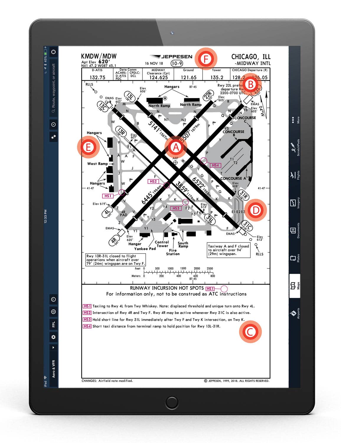
Think of a taxi chart like a road map, assuming you’re old enough to remember one of those. Without charts on their kneeboards or iPads, pilots might have no idea of where they’re expected to taxi before ground control begins issuing clearances. The airport diagram helps pilots understand taxiway and runway identifiers, as well as potential runway crossing locations.
B. Notes, Notes, Notes
While most of us don’t fly aircraft with a wingspan greater than 79 feet, a note on this chart explains to pilots who do that aircraft headed for taxiway F are prohibited from landing on Runway 13R/31L. In another, taxiways A and F are closed to aircraft more than 94 feet wide. Pilots using MDW at night will find a note near the top that tells pilots to expect Runway 22L between 2200-0700 local time. Interestingly, the chart says the use of 22L for noise abatement is based on UTC, not local time. A call to the city of Chicago’s Department of Aviation uncovered an error in the chart that was reported to Jeppesen. It should read local time, not UTC.
C. Hot Spots
In an effort to help reduce runway incursions, a few years ago the FAA began incorporating real-world data to taxi charts by identifying and charting hot spots, where the risk of an incursion is greatest. Hot spots are designated on a chart with an “HS” and a number with a circle. When taxiing, this is a reminder to pilots to be on high alert for taxi instructions that could be misinterpreted based on what the pilot sees from the windows. For example, HS1 at MDW is located where taxiing aircraft on “Taxiway Whiskey” just might miss the hold short lines for Runway 4L.
D. Symbols are Key
Not every chart explains the ramifications of the symbology, but many offer the pilot a hint to look somewhere else for added information. For example, on the MDE chart, RWY 13C/31C shows white bars crossing the runway near the approach end. These highlight a displaced threshold on that 6,522-foot surface. That means the entire length of Runway 31C is available for takeoff, but not for landing. The pilot must look to the airport facilities directory supplement for the usable landing distance of 5,826 feet. Another unique symbol on this chart is the square marked EMAS, a runway-overrun arresting system.
E. Parking Arrangements
While taxi charts don’t necessarily list the location of every FBO, pilots will find listings of “Hangars.” They will need to check additional resources for precise location and should do so before they land in order to be prepared for big-city controllers who might, at times, speak rather quickly. Studying the FBO location offers the pilots a heads up on potential taxi routes after arrival.
F. Frequency Planning
Pilots departing MDW will need to transition through multiple radio frequencies to receive the information needed to reach the point of takeoff. A review of the frequencies tab at the top of the chart shows not only the frequency for ATIS, Tower and Departure, but displays them in the order the pilot would use them; first ATIS, the availability of controller-pilot datalink communications, then clearance delivery, then ground, tower and departure control. Each note helps plan what to expect next.

Sign-up for newsletters & special offers!
Get the latest FLYING stories & special offers delivered directly to your inbox

