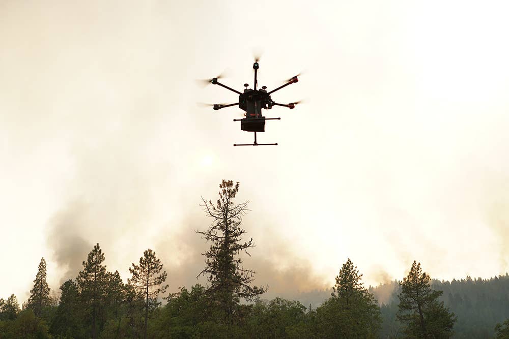
Drones are sometimes used to set strategically located fires intended to burn vegetation
that might fuel an oncoming wildfire. Courtesy: Drone Amplified
On a smoky mountain slope, an exhausted firefighter scans the hazy horizon around her. Beyond a line of flames, she can see a small town in the distance. She kneels down, reaches into her backpack, and pulls out a small quadcopter drone.
After launching it into the air, the drone’s autopilot takes control, flying the aircraft high over the fire. It sends data to the firefighter’s hand-held device about changes in wind direction and wind speed. The drone also sends GPS coordinates showing the exact location of the fire’s front line, as well as the location of her team. A thermal camera on the drone allows her to see through heavy smoke and keep her team out of harm’s way.
Lifesaving backpack technology as sophisticated as this isn’t available to firefighters. But it could be soon, as engineers work to take firefighting drones to new heights.
Fighting wildfires with drones isn’t new. The U.S. Department of Interior started flying unmanned aircraft systems (UAS) a decade ago to help map fires and determine their direction. More recently, drones have been developed to find a fire’s hottest spots and to strategically set controlled fires that eliminate potential wildfire fuel. Drones are also planting seeds across fire-ravaged areas to replenish forests and grassland.
Developing better drones to more effectively fight wildfires couldn’t come at a better time. Summer wildfire seasons in North America are getting longer and more devastating. Scientists say the amount of land burned by severe fires has been increasing in western U.S. forests since the 1980s. This year, so far, the U.S. has seen more than 46,000 wildfires burning nearly 6 million acres nationwide.
The KHawk
An experimental UAS program led by professors at Georgia State University, the University of Missouri and the University of Kansas is aiming to raise the technological bar when it comes to firefighting drones.
“This is a very active field of study now, and a lot of progress has been made,” Georgia State’s Dr. Xiaolin Hu told FLYING.
Their drone—named KHawk—is a quadcopter design that weighs about 5 pounds and measures around 3 feet by 3 feet, Hu said. It includes an autopilot system, a thermal camera, and other specialized avionics.
It’s designed to fly autonomously with ground supervision, while transmitting information about winds and fire, including predictive data about where the flames may spread next. Ideally, it would “issue an early warning to firefighters if they’re in danger,” Hu said.
“I’m not aware of any other technology like we’re working on that would offer this kind of data in real time,” Hu said.
A significant challenge for the KHawk program has been overcoming winds and turbulence stirred up by intense heat.
“Designing small, portable wings that will keep the aircraft stable during wildfire conditions with strong winds remains an issue,” said Dr. Haiyang Chao, who works on KHawk at the University of Kansas. “Flying small drones safely under these conditions is important.”
Engineers have been testing the drone’s performance while flying over controlled burns in Kansas, collaborating with private landowners and wildlife experts. The U.S. Department of Agriculture is funding the project. If all goes as planned, KHawk is expected to begin flight testing in real-world scenarios in two years.
Dropping Tiny Fire Bombs
The use of wildfire-fighting drones has grown quickly. The U.S. Department of Interior (DOI) started flying drone missions in 2010 with about 200 total flights. By 2019, as the DOI and other wildfire agencies started increasing their drone fleets, firefighting flights had increased to 2,389. Last year, that number dropped to 1,887—likely down because of reduced operations during the height of the COVID-19 pandemic.
Initially, firefighting drones were used for observational missions, outfitted with video cameras and infrared heat sensors. And it proved to be successful.
“Adding drone support to fire suppression efforts could dramatically reduce the size and cost of wildfires, potentially saving millions of dollars and hundreds of thousands of acres with triple the hours of critical aviation support,” said Jeff Rupert, DOI director of the Office of Wildland Fire, in a 2017 news release.
The next year, the DOI expanded the mission of its drone fleet and began the first use of UAS for aerial ignition operations: using drones to start fires.
Firefighters have long used a strategy of intentionally starting fires to burn vegetation that would otherwise provide fuel for wildfires. These are known as controlled burns and back burns. Setting a fire intended to burn back toward the main fireline denies the main fireline enough fuel to continue forward, ultimately starving and snuffing out the flames.
Igniting back burns with firefighters on the ground using drip torches can take hours. Dropping igniting devices from helicopters is expensive and often dangerous. That’s where drones come in.
A Lincoln, Nebraska-based company called Drone Amplified has invented a drone payload system called IGNIS (Latin for “fire”), which has become embraced by federal agencies as a key weapon in the war on wildfires. Drone Amplified founder and CEO Carrick Detweiler, who’s also an associate professor of computer science and engineering at the University of Nebraska-Lincoln, co-invented IGNIS and developed it from an idea that came out of his research lab.
Here’s how it works: Commercial drone platforms outfitted with IGNIS carry a basket filled with what are called ignition spheres resembling Ping-Pong balls.
Essentially, these things amount to tiny fire bombs.
Each sphere is filled with a chemical called potassium permanganate. While in flight, IGNIS punctures and injects each ball with another chemical called glycol. Combining the two chemicals starts a reaction that ignites each ball within 30 to 60 seconds. The spheres are designed to burn for two minutes. That’s enough time for an ignited sphere to fall from the drone, land on the ground and start a fire.
Fully loaded, the IGNIS payload weighs 4 kg (8.8 lbs) and carries 400 tiny fire bombs. It can drop as many as 120 balls per minute—or two every second. It includes cameras, high-temperature sensors, autonomous capability, and a remote emergency release system.
At this rate, a single drone with an IGNIS payload can cover up to 4,300 acres in eight hours, according to the company. Operators pilot drones with IGNIS using an app and a computer tablet. Spheres and chemicals can be reloaded in five minutes.
Drone Amplified made a bit of aviation firefighting history when the DOI first used IGNIS operationally in 2018. The payload was flown 177 times for a total of more than 50 hours that year. It also allowed the DOI to perform its first-ever aerial ignition operation at night.
Two years later, in 2020, IGNIS helped put out Colorado’s Pine Gulch Fire, one of the largest wildfires in state history.
Almost 100 IGNIS systems are now “out in the wild, being used on pretty much all the major wildfires,” Detweiler told FLYING.
“Flying low and slow over fires is one of the most dangerous operations pilots can do,” Detweiler said. “So if you can avoid using a helicopter to perform these ignitions, and save that for transporting people and for water drops, and other missions, you’ll have that many more aviation resources available to you.”
Air Traffic Control
To drop ignition spheres from drones, pilots are required to have additional training, carding, and certification, including an FAA Part 137 agricultural operator certificate.
In fact, U.S. wildfire drone operators are required to hold a valid FAA remote pilot certificate, complete agency remote pilot training and pass a proficiency flight test. Flying beyond visual line of sight or above 400 feet agl requires special FAA permission.
During wildfire operations, a designated air traffic controller on the ground coordinates drones and firefighting airplanes sharing the same airspace.
Federal authorities keep unauthorized aircraft from entering air space around a wildfire by issuing a temporary flight restriction (TFR). The FAA and DOI make information about wildfire TFR locations available to private drone pilots to help keep them from accidentally flying into these zones.
Nonetheless, between 2014 and July 2019, federal officials tracked more than 153 drone incursions nationwide during U.S. fire suppression operations. These drones had “potential to cause an aircraft mishap resulting in aircraft damage, personal injury or death,” according to the DOI.
Planting Seeds for the Future
Another way drones are being used to fight wildfires happens months after the fire is over.
Companies such as U.K.-based Dendra Systems and DroneSeed, based in Seattle, have developed large quad-copter drones that fly in swarms—autonomously in patterns—spreading seeds for new trees.
The idea is to return blackened, fire-ravaged forests to health as soon as possible, to prevent further damage to the land by erosion and mudslides.
Traditionally, reforestation has been a slow, painstaking process—using workers to transplant seedlings by hand.
Emerging UAS technology now allows land managers to accelerate the reforestation timeline six times faster than by hand planting, according to DroneSeed.
“We go out with a small team to perform a site survey and build a 3D terrain map that informs us of the best places to drop the seed vessels,” said DroneSeed founder and CEO Grant Canary.
Then, at each site, swarms of three to five drones are deployed to begin spreading seeds. When power gets low, the drones land, to allow operators to change batteries quickly.
“It’s very much like a NASCAR pit crew,” Canary said, “because time on the ground is time that we’re not reforesting.”
The company, which began operating in 2016, obtained rare FAA approval last year to fly multiple drones weighing more than 55 pounds beyond line of sight (BLOS). It became the first company in the United States to win legal approval to operate with heavy-lift drone swarms, according to DroneSeed.
In the near future, DroneSeed plans to expand its supply chain, with the recent acquisition of a seed bank called Silvaseed. It also aims to increase its production capacity for growing seedlings. For aerial operations, DroneSeed is looking to develop heavier drone payloads and longer flight times, Canary said. “Those are the two things that we’re consistently working toward.”
Overall, in the coming decades, it’s clear that remotely piloted aircraft will play an increasingly important role as land managers consider new strategies for fighting wildfires.
“There’s still a lot of shovels and drip torches out there in the firefighting world,” said Drone Amplified’s Detweiler. “So there’s a huge need for new technologies and companies that are focused on solving problems.”

Sign-up for newsletters & special offers!
Get the latest FLYING stories & special offers delivered directly to your inbox

