Relevant Discussion: AIM 5-4-5, 7-1-11, 7-2-1 through 7-2-5, P/C Glossary, FAA-H-8083-16, AC 00-45, AC 91-70, AC 120-28D, Order 7110.65T
Q codes are basic three-letter telecommunications codes designated in the early 1930s, back when Morse code was still the most popular form of long-distance information exchange, to facilitate the transmission and reception of common questions and answers.
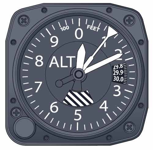
QNH — The barometric pressure as reported by a particular station (local altimeter setting). QNH is the altimeter setting that most general aviation pilots are familiar with when operating in the United States and Canada below 18,000 feet msl. This setting causes the altimeter to read field elevation (above sea level) when the aircraft is on the ground. Most overseas airports give altimeter settings in hectopascals (hPa), aka millibars (mb). Therefore, it is imperative that pilots are able to convert inches of mercury to hectopascals and hectopascals to inches of mercury. One mb equals 1 hPa, so there is essentially no difference in the two terms as far as the pilot is concerned. The United Kingdom uses an additional term called "regional QNH," which is the lowest forecast QNH in an altimeter setting region.
QNE, aka pressure altitude, aka ISA standard pressure — The uncorrected (for temperature) altitude indicated by an altimeter when it is set to 29.92 inches of mercury (inHg), or 1013.2 mb/hPa. It is the standard altimeter setting used in controlled airspace at or above transition altitude (18,000 feet msl in the United States and Canada). Controllers in the U.K. refer to QNE as the standard pressure setting (SPS). Pressure altitude also is used to compute density altitude, true altitude, true airspeed and other performance data.
Transition altitude (or transition height, when using QFE) is the altitude/height above which standard pressure (QNE) is set (29.92 inHg or 1013.2 mb/hPa). The United States and Canada use 18,000 feet msl as the transition altitude to switch from the local altimeter setting (QNH) to pressure altitude (QNE) when climbing through 18,000 feet. "Transition altitude" normally refers to climb situations. Here's a memory aid: The A in "altitude" points up.
Transition level is the flight level below which QNH (local altimeter) or QFE is set. "Transition level" normally refers to a situation in which you are descending. The useful memory aid for this one is that the V in "level" points down.
In North America, transition altitude and transition level are the same: 18,000 feet, aka FL 180.
Transition altitudes/levels vary from country to country and can vary from airport to airport within a country. They can be found in the Altimeter Setting Data Box on en route charts, STARs, approach charts, departure procedures, and/or broadcast on ATIS or assigned by ATC. Transition altitudes/levels may be designated anywhere from 2,000 feet msl to 20,000 feet msl depending on the country or the individual airport. These altitudes can also be different when climbing away from or descending down to the same airport.
Transition layer is the airspace between the transition altitude and the transition level. Aircraft descending through the transition layer will set altimeters to local station pressure, while departing aircraft climbing through the layer will be using the standard altimeter setting (QNE).
QFE — The altimeter setting referenced to airport field elevation where field elevation equals zero feet. QFE is the actual surface pressure at the airport. The altimeter will read zero feet when the aircraft is on the ground. When QFE is used, a barometric pressure equivalent must be listed on the approach chart to establish a height reference for landing (height above QFE level).
There are two types of QFE:
a. Airfield QFE — The highest point on the airfield. b. Touchdown QFE — Measured at the touchdown point of the runway for precision approaches. Russia is in the process of transitioning to the use of QNH and feet below the transition level, so there will be very few places left requiring the use of QFE. However, you will need to be cautious when flying in countries that used to be part of the former Soviet Union. Pilots with recent experience are a great source of information.
- Meters versus feet — If you see a feet-to-meters conversion table on a country's en route or approach chart, you will probably be assigned altitudes in meters. International Civil Aviation Organization procedures (altitudes in feet) are used pretty much universally, with the exceptions of North Korea and parts of China. As a general rule, if the chart says "Alt Set: hPa" and you don't find any metric conversion tables, you're probably dealing with ICAO standards and can expect to set the altimeter to QNH and use feet instead of meters. When flying to these countries, it's also a great idea to bring along a few wheelbarrows full of cash to cover those all-important "handling fees."
Example: 1 mb = 1 hPa Convert (altimeter setting) inches of mercury (inHg) to millibars (mb), aka hectopascals (hPa) — 1 inch of mercury (inHg) = 33.863 millibars (mb), aka hectopascals (hPa) (29.92 times 33.863 equals 1013.2 hPa) (1013.2 hPa divided by 33.863 = 29.92) Metar/TAF: Altimeter setting in the United States — inches and hundredths — A2992 = 29.92 Other countries: Q — hectopascals, or millibars, and tenths — Q1013.2
Also: Some altimeters do not show decimals for hPa or mb. In such cases, select the nearest value.
FAA regulations could change at any time. Please refer to current FARs to ensure you are legal.

Sign-up for newsletters & special offers!
Get the latest FLYING stories & special offers delivered directly to your inbox


