Navigating Smoke
Smoke can present a hazard to all pilots, but especially those flying under visual flight rules.

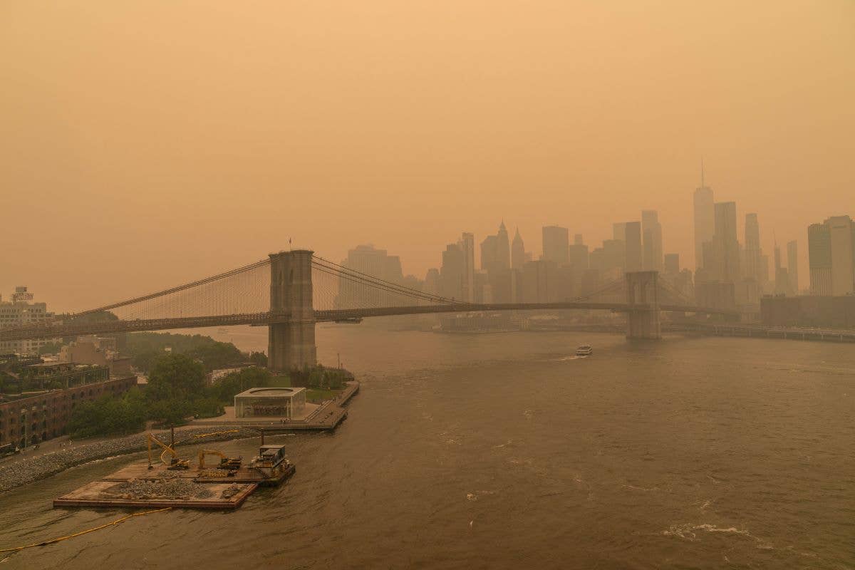
Smoke from Canadian wildfires brought in by wind created a hazy New York city skyline June 7, 2023. [Credit: Shutterstock]
Given the dozens of forest fires burning out of control in southeastern Canada, mainly in Quebec and Nova Scotia, I have received many inquiries from my followers about how to deal with smoke from an aviation perspective. First and foremost, smoke can present a hazard to all pilots, but especially those flying under VFR.
Smoke lowers visibility, not only at the surface, but aloft as well. It is not unusual for smoke to lower flight and surface visibility to less than 1 statute mile, making flying VFR impossible and dangerous, especially at night and in mountainous terrain. Even under IFR, visibility may be in the low IFR flight category and below published minimums for some airports. In fact, the FAA implemented a ground stop for flights bound for New York’s LaGuardia airport because of smoke and reduced visibility on Wednesday.
So, what’s a pilot to do? If you don’t have to fly, that’s likely the best option. If you do decide to make the flight, it’s best to be on an instrument flight plan. Also, if you have oxygen on board, consider using it even below 10,000 feet. In fact, wearing an oxygen mask is always a good approach.
All smoke contains some carbon monoxide, carbon dioxide, and other particulate matter. Hemoglobin bonds with carbon monoxide 200 times more readily than it bonds with oxygen, and often produces hypemic hypoxia. Depending on what is actually burning at the surface, smoke can contain a variety of different chemicals, including aldehydes, acid gasses, sulfur dioxide, nitrogen oxides, polycyclic aromatic hydrocarbons (PAHs), benzene, toluene, styrene, metals, and dioxins. None of these are good to breathe, especially if you have health issues (also consider your passenger’s health).
The smoke starts as eddies in the planetary boundary layer (PBL). This is the layer of air that is directly influenced by the earth’s surface. But then some of that air gets mixed above the PBL into the free atmosphere, and encounters stronger horizontal winds. Smoke from these fires can travel thousands of miles. In fact, some of the smoke from the Canadian fires has reached as far south as the Carolinas and northern Georgia, albeit in low concentrations of particles.
In the early morning hours, the atmosphere around the regions where the fires are burning is often fairly stable near the surface. That will trap some of the smoke, keeping it close to the surface. The fires burn so hot that they often produce convective updrafts along with “clouds” called pyrocumulus, pyrocumulus congestus flammagenitus, and cumulonimbus flammagenitus (with lightning) that carry the smoke high into the flight levels. These “clouds” don’t produce any rain, but those updrafts can contain severe turbulence that manifests as strong surface winds, which can exacerbate a large conflagration.
However, later in the day as the sun starts to heat the ground, that smoky air higher up moves downwind and it gets mixed down to the surface via turbulent mixing that occurs in the prime heating of the day. And that’s how you get some of that smoke to show back up near the surface at distances hundreds of miles from the origins of the fires.
Look for FU in the terminal aerodrome forecast (TAF) or in METARs. FU is an abbreviation for smoke from the French word fumée, as you can see below from this TAF for the Syracuse Hancock International Airport (KSYR). Notice the visibility is forecast to be as low as 3/4-statute miles in the early afternoon. This is in the low IFR flight category.
In fact, Syracuse was reporting 1/2-statute mile visibility earlier in the morning, as shown below. The bad news is that obscurations, such as dust, smoke, and blowing sand are not automatically reported by ASOS or AWOS. At airports with a trained observer, they can augment the observation by adding FU to the METAR, as occurred at Syracuse.
KSYR 071354Z 29010KT 1/2SM R28/P6000FT FU BKN027 OVC150 15/04 A2969 RMK AO2 SLP048 FU OVC150 T01500044
What about using model output statistics or MOS? These forecasts are made available in some of the popular heavyweight apps. Here’s more bad news. Unfortunately, MOS doesn’t account for smoke in the visibility forecast. The TAF is much more reliable when smoke is expected in the terminal area. Those are issued by highly trained forecasters who can account for the effects of smoke. The Localized Aviation MOS Program (LAMP) does advect observational data such that in the first few forecast hours, you will see the LAMP pick up on lowered visibility reported at airports, but beyond those few hours, it will quickly tend to discount the effects of smoke since it doesn’t really have data to support this phenomenon. Certainly, this area of research will eventually integrate smoke into the MOS forecasts in some future release.
I like to use the smoke forecast from the High Resolution Rapid Refresh (HRRR) model, which you can find here. HRRR-Smoke uses infrared (IR) satellite data to start. We know that fires create heat anomalies and that will show up nicely on IR satellite data. So, it’s not just about the smoke. Using this information means that the model is determining where the source of the fires are located. Once that information is known, it relies on changes in temperature, wind, water vapor, and precipitation to predict where the smoke will eventually end up in the atmosphere. Keep in mind that this is an experimental forecast.
The HRRR-Smoke is refreshed hourly and produces a forecast out to 18 hours, but for runtime hours divisible by six (00Z, 06Z, 12Z, and 18Z), it can provide a forecast with lead times out to 48 hours. There are four different loops that can be used to include near-surface smoke, 1,000-foot agl smoke, 6,000-foot agl smoke, and vertically integrated smoke. It’s a good idea to look at all four.
For departing or approaching an airport, the biggest concern is the conditions that might occur when landing or taking off. Near-surface smoke gives you smoke concentrations at about 8 meters (26 feet) above the ground. As shown below, this is indicated on a pale-blue to deep-purple color scale at the bottom of the forecast map. As you might expect, the northeast, especially New York and Pennsylvania) is currently covered in a smoky haze—purple and red are really bad, while light blue indicates relatively low concentrations (measured in micrograms per cubic meter of air). You can see below that smoke near the surface has traveled as far south as South Carolina and Georgia with fairly high concentrations.
Instead of measuring smoke around 8 meters off the ground, vertically integrated smoke is modeling what a 25-kilometer-high column of air looks like over any given location. The best way to think of this is as the smoke you can see covering the entire sky vs. the smoke near the surface you can smell. As you can see below, smoke covers most of the country east of the Mississippi River. The scale is a bit different in the magnitude of the numbers, but warmer purple-red colors are still very bad, and the cooler pale blue colors represent much lower concentrations.
Even with these forecasts, on any given day it’s extremely difficult to get a sense of what flying conditions will be like at cruise altitude. How high do you need to climb to be on top of the smoke, assuming you can fly high enough to even get on top? There isn’t a good answer. Certainly, in regions where high concentrations exist using the vertically integrated smoke forecast, expect smoke from the surface well up into the flight levels. In other regions, smoke can often top out at 15,000 feet or so, with higher concentrations below. It just depends on the current conditions, including wind direction and atmospheric stability.
The best strategy is to look for pilot weather reports that often will point out where the top of the smoke is located. As with all pilot reports, when the smoke is really bad, pilots will often avoid flying through the area. If you do happen to fly on a smoky day, please take a few minutes to document what you experienced and submit a report.
How long will this be with us? That depends on two factors. First, can most of these fires be contained? This largely depends on Mother Nature; without ample rainfall, honestly, there’s little hope. The second factor depends on how long the stagnant air will remain in place. Given the blocking omega weather pattern that has set up across the entire U.S. and southern Canada over the last few weeks, it might be with us for a couple more weeks.

Sign-up for newsletters & special offers!
Get the latest FLYING stories & special offers delivered directly to your inbox


