Responders Turn to Drones Amid Hurricane Recovery
Uncrewed aircraft give public safety, utility, and infrastructure providers an eye in the sky.
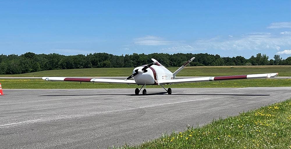
Mississippi State University’s Raspet Flight Research Laboratory deployed a large uncrewed aircraft, Teros, to assist with post-Helene recovery efforts. [Courtesy: Mississippi State University]
As Americans in the Southeast attempt to return to normalcy in the wake of Hurricane Helene and prepare for impending Hurricane Milton, which is expected to make landfall near Tampa, Florida, Wednesday night, drone operators are doing everything they can to help.
“While helicopters are invaluable for their range and payload capabilities, drones complement these assets by offering quicker, more cost-effective deployment,” Skydio, one of the largest U.S. drone manufacturers, told FLYING. “Their ability to operate in challenging conditions—including wind and rain—and their capacity for remote operation from anywhere via a web browser enhances the overall safety and efficiency of the response efforts, ensuring broader and more flexible coverage.”
Since shuttering its consumer drone business to focus on selling to enterprise and public safety customers last year, Skydio has assisted operators with plenty of disaster response and recovery efforts. Even before then, the company said it provided assistance following Hurricane Ian in 2022.
“Skydio team members—many of whom live in the communities their customers serve—closely monitor developing situations such as these, proactively deploying resources to impacted areas and supporting on the ground and in real time,” the company said.
In the wake of Helene, Skydio customers are deploying drones for search and rescue, overwatch, and damage assessment. Since the storm damaged many bridges in the most affected areas, for example, customers are using drone inspections to create digital twins, helping them assess safety and accelerate the repair process.
The company said it surged available personnel, remote connectivity systems, and its X10 and X10D drone models—equipped with spotlight attachments—to regions most in need, including the Florida Panhandle and western North Carolina.
Skydio has been working with local, state, and federal agencies to prepare for and respond to Helene, including the city of Tampa, Punta Gorda Police Department, and Southern Company.
Southern Company, an electric and gas utility provider, enlisted Skydio drones to perform damage assessments with “unprecedented speed and efficiency,” per Jonathan Tinch, an uncrewed aircraft systems (UAS) pilot and safety coordinator for the company.
The aircraft collected high-resolution images and real-time video of the damage, transmitting them to a command center. There, they were analyzed by experts who directed ground crews to the areas most in need of repair.
“As a result, we were able to restore power to our customers more quickly than ever before,” said Tinch.
As another major hurricane approaches, Skydio said it will offer further support.
"After what we saw in Asheville and the impact of drones there, we have doubled our efforts to support agencies responding to Milton," Skydio told FLYING. "We have a team of people holed up in an Airbnb in northern Florida poised to be on the ground in the Tampa area the minute the storm clears and it is safe to travel."
Also assisting with post-Helene recovery efforts are pilots, engineers, and scientists from Mississippi State University’s (MSU) Raspet Flight Research Laboratory.
Raspet, backed by Project JUSTICE—a program within the U.S. Department of Homeland Security’s Science and Technology Directorate designed to learn about uncrewed systems by sending them on real-world missions—is supporting the Federal Emergency Management Administration (FEMA) with a massive UAS called Teros.
Built by Navmar Applied Sciences Corporation, Teros has a 44-foot wingspan and can remain aloft for 20 hours, allowing it to perform long-duration missions. Raspet deployed to Georgia on September 29 to assess post-hurricane flooding.
“Once a hurricane has passed over an inland area, the water it leaves behind is constantly moving, and that movement can be difficult to predict, especially in places where trees and other barriers might obscure water from satellite imagery,” said Jamie Dyer, a geosciences professor at Mississippi State and associate director of the university’s Northern Gulf Institute (NGI).
NGI experts tracked Helene through the Gulf of Mexico and Florida, Georgia, South Carolina, North Carolina and Tennessee. Using Teros’ sensors and cameras, they collected real-time data and visuals on the movement of floodwaters, beaming it to federal entities like FEMA and the National Oceanic and Atmospheric Administration (NOAA).
“UAS allow us to see in better detail where water is going and which areas will be impacted by flooding, which is vital information to have during a crisis event,” said Dyer. “Additionally, the data we collect will improve the river forecasting models that local, state and federal officials rely on.”
State officials with the North Carolina Department of Transportation’s Division of Aviation have also deployed drones to survey roads, bridges, and other infrastructure, flying more than 200 missions in the past week alone.
Over at NOAA, meanwhile, “hurricane hunters” are flying a pair of Lockheed WP-3Ds and a Gulfstream IV-SP—affectionately nicknamed “Kermit,” “Miss Piggy,” and “Gonzo”—directly into the eye of Hurricane Milton. Some of these missions will deploy Blackswift S0 UAS to measure temperature, pressure, wind, and humidity, which can help predict a storm’s path.
The FAA advises individual drone users or hobbyists to be mindful of temporary flight restrictions (TFRs) in place around hurricane-affected regions. Pilots who neglect to coordinate with local emergency services could inadvertently hinder their efforts, so noncommercial operators should exercise caution.
Like this story? We think you'll also like the Future of FLYING newsletter sent every Thursday afternoon. Sign up now.


Sign-up for newsletters & special offers!
Get the latest FLYING stories & special offers delivered directly to your inbox