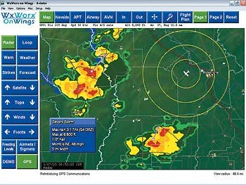
WxWorx on Wings, the weather products that XM Satellite Weather downlinks from satellites to our cockpits, is provided to XM by Baron Services' WxWorx. The weather products are collected at two distinct collection points, one located at WxWorx's headquarters in Huntsville, Alabama, and the other inside the National Climatic Data Center (NCDC) in Asheville, North Carolina. The two collection points are part of the redundancy that WxWorx has carefully built into its system.
Continuing the effort at redundancy, the weather data is delivered by both satellite and high speed internet to the collection centers. "In most cases," explained Bob Baron, founder, CEO and president of Baron Services, "we have double redundancy." As soon as WxWorx receives the information the data stream is automatically sent to XM over a dedicated line and two internet connections. Again, the object is to have no single point of failure. The transmission goes to XM Satellite Weather's operation center and is inserted into its uplink to both of its satellites and broadcast over all its relay stations on the surface of the earth.
"The collection of the data is ongoing and can be measured in nanoseconds," Baron said. "It takes 15 seconds or less for us to process the information and ship it. The delay between when we ship it and when it reaches an aircraft is on the order of 20 or 30 seconds. The delay can vary a little by load, but within 30 seconds it's in the cockpit."
Although the time the data takes to get from WxWorx to the cockpit is almost simultaneous, the data is not "real time." Nexrad (next generation radar) images are recorded by an array of 141 radars spread around the country and one in Puerto Rico. The radars are Doppler radars that record the echo intensity (reflectivity) of precipitation or other particles in the atmosphere measured in dBZ (decibels of Z, where Z is the energy reflected back to the radar). So, "reflectivity" is the amount of transmitted power returned to the radar receiver and that intensity is presented as levels by color.
There are two types of Nexrad images created by each radar station. One image displays base reflectivity and the other presents composite reflectivity. To understand the difference, it's necessary to realize that the first revolution of the radar antenna is at an elevation of 0.5 degrees above the horizon and that the angle of elevation increases on subsequent revolutions 13 times before returning to the original 0.5 degrees. The base reflectivity image shows the reflected energy from the sweep at the lowest elevation, the base.
According to Baron, it takes about 20 seconds for each 360-degree sweep of the radar, so it takes about five minutes for the radar to complete a "volume" scan of the 14 layers using the antenna's different tilt angles. With base reflectivity the atmosphere that is sampled is about 300 to 400 feet above the ground close to the radar site and between 20,000 and 30,000 feet at the far end of the beam. The base reflectivity image is only available once every five minutes, since it takes that long for the radar to get back around for the new lowest level cut of the atmosphere.
The composite reflectivity Nexrad image, on the other hand, displays the greatest reflectivity from all 14 of the elevation scans.
"What we choose to do," Baron explained, "is pull all the data the radar has to offer and do a composite of each of the radars. For example, at a specific time, say 10:00 a.m., we'd take the latest scan that each of the radars has done, whether it was the base, halfway up or at the top. And then we'd go back and take the data that had been recorded five minutes earlier and that way create a complete look at the atmos-phere."
Every five minutes a composite image that combines the most recent weather received by the radars with that of the weather five minutes earlier is sent to XM for uplink to the satellite. According to Baron, the positive effect of creating the image that way is that "we don't miss anything because we're not undershooting or overshooting the weather."
The disadvantage, he said, is that the image shows the worst conditions in the atmosphere and goes back five minutes. "It overstates the negative, but we prefer to err on the side of too much rather than too little." WxWorx claims to be the only weather vendor that processes the Nexrad data using its own algorithms. According to Baron, by processing the data itself, WxWorx is able to provide better information about the weather. The government weather service, he said, processes the data at the end of the volume scan, "but we're processing it as we go. As we get each level we're looking at specific things. For example, looking at things like hail or tornados can be processed earlier by not waiting for the end of the scan. We like to think ours [algorithms] are better, but maybe it's conjecture." Each of the composite images, combining all of the cuts from each of the 142 radars that make up the Nexrad array, are put together to form a mosaic that allows a seamless image to be displayed in the cockpit. The resolution of the display is made up of blocks that are two kilometers square or about a mile square. In other words, any precipitation that the radar detects in that two kilometer block of airspace will be shown, at its greatest intensity, to fill the entire block.
Anomalous propogation (AP), a false reflectivity echo that is not precipitation but may be produced by unusual rates of refraction in the atmosphere, can be a problem when interpreting the Nexrad image. WxWorx uses a software program to automate the elimination of AP. According to Baron, most of the AP is eliminated by the automatic program.
"But it's a little bit challenging. We seek to automate it as much as possible so we can get the information to the cockpit as rapidly as possible. Nevertheless, there are times, normally in the spring or fall, when the automatic system believes there's precipitation when there's not and we get some anomalous propagation."
Although the automatic system "works pretty darn well," occasionally there has to be intervention from WxWorx's 24/7 forecast team. A brand new facility in Huntsville, described as "a Starship Enterprise," and a new process that will allow cleaning up the AP instantaneously is in the works, "so we won't have any delay in the radar product," Baron said.
According to Baron, the metars are instantaneously collected a little before each hour and inserted into the data stream. "We send the metars on a 12-minute schedule. We wanted a pilot to be able to get the metar before taking off and figured it would be 12 minutes before they'd complete their run-up. In that time they'd also have two radar images before taking off." The satellite images take about 15 minutes to be digitized and shipped back to earth at Wallops Island where they're massaged for accuracy and then distributed.
"The new ones are 15 minutes old when we get them, but by the time they're downlinked to a cockpit they can be as old as half an hour because of the way they're collected," Baron said. It's been said before, but Baron reiterated that the weather products "are for situational awareness, not a tactical tool. The rules of thumb that have been in place are the rules of thumb pilots still need to follow. You don't want to cut it too close to a thunderstorm. The rule of at least five or 10 miles from a thunderstorm and 20 miles from a super cell is still valid advice. The advantage we have with the equipment today is we can tell how far away we are."
As pilots we should be thankful that while everybody talks about the weather, we've got WxWorx doing something about it.

Sign-up for newsletters & special offers!
Get the latest FLYING stories & special offers delivered directly to your inbox

