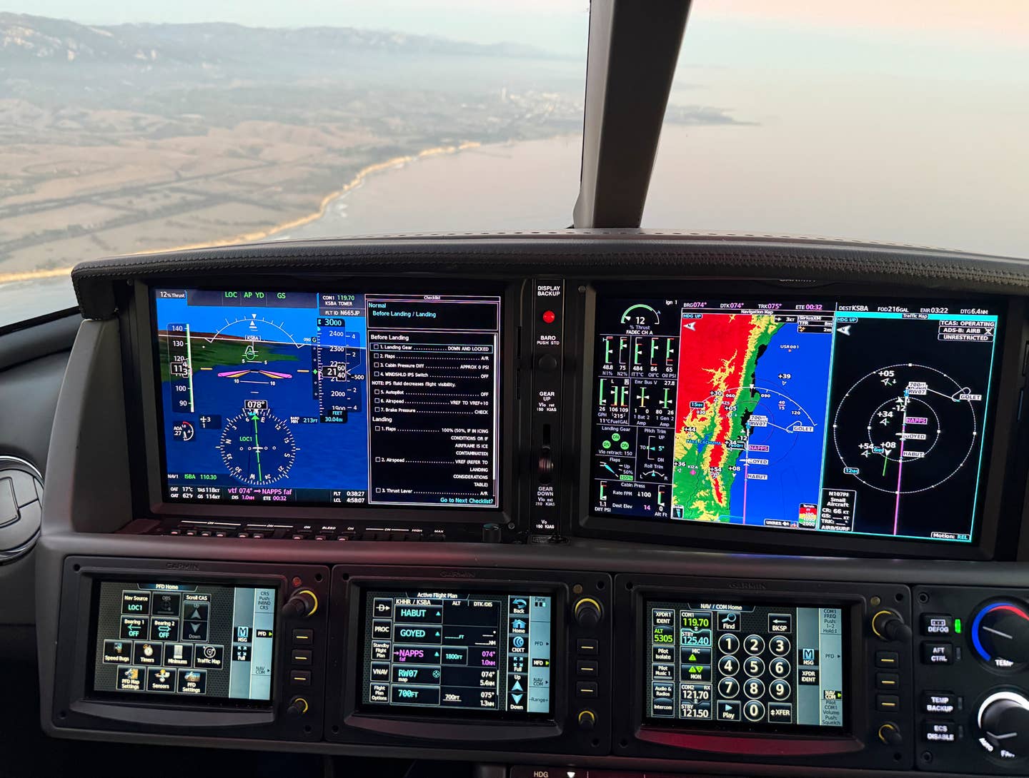
Every pilot who stays reasonably up to date with the march of aviation technology knows that today even pilots of piston singles and light twins can get aviation weather in the cockpit. For those pilots who fly their airplanes for transportation, this is nothing short of a safety revolution. Instead of guessing and hoping and sweating, we can now fly with a high degree of confidence that we'll be able to avoid severe weather. This information also allows us to make better strategic in-flight decisions, including modifying routing, altitudes and diversions. Say you're 250 miles out. How's the weather at the destination? Instead of waiting until you're almost in the pattern, check out the conditions at the destination, and if it's too low, make a new plan before you find yourself in the middle of some crud you'd wish you'd never gotten close to.
Getting weather information is huge, but datalink can also give pilots updates on airspace changes, most notably areas of temporary flight restrictions (TFRs). This is a big deal, especially for VFR pilots who, even if they're getting flight following, have no guarantee of staying clear of restricted airspace. If a TFR pops up suddenly, or if its limits grow, say when the President stops by his ranch in Crawford or Camp David, as soon as the receiver gets the updated data, the TFR will show up on the map. It's great peace of mind.
Not Whether to Buy, But What to Buy
While everybody is ecstatic that high-quality weather information is available, the proliferation of these products has made for a confusing marketplace for pilots looking to get into the game. The big questions for would-be adopters: What weather is available, what can you play it on, and how much does it cost?
Pick a Package
Standardization isn't unknown in aviation electronics, but when it comes to newer technology, it is definitely the exception. So unlike, let's say, a satellite television receiver, which you can plug in to just about any kind of TV, aviation weather receivers play on a limited number of displays. Often, that limited number is one. Consequently, when you go to pick out a weather service provider, you're usually choosing a display and an avionics manufacturer as well. So the easiest way to approach a purchase is to pick a package and go for it. But which one? Ground-up or Sky-down? Broadcast or Two-Way?
There are essentially two kinds of weather pipelines available, those that make use of some kind of satellite network and those that are built around VHF ground transmitters. Unlike satellite systems, ground-based systems are limited by terrain and the airplane's proximity to the station. But VHF is still widely and effectively used by the airlines with ACARS datalink for exchanging a variety of data-weather, clearances, and text messages-over the airwaves. General aviation has a VHF system, Bendix/King's broadcast-only Flight Information Services program, developed as part of an FAA program to promote datalink weather for the cockpit. For pilots who primarily fly in the most populous parts of the country, Bendix/King's FIS datalink offers a powerful suite of weather products, including Nexrad and graphical metars. As part of the company's contract with the FAA, you can even get free textual weather in a properly equipped airplane.
Because it was prohibitively expensive and required large, hi-gain antennas that don't fit on every airplane, satellite weather was once the exclusive domain of the biggest bizjets. But since the launch of several lower cost satellite weather options, including Echo Flite, WSI and XM aviation weather, satellite-based weather is a powerful and affordable option. The biggest benefit is that the signal comes from above, so unless you're flying under bridges or through tunnels, reception is pretty much a given (though some early adopters found that updates from some sat systems were slow to come by). And because satellites each cover a large geographical area, coverage is widespread, though pilots of these lower-cost systems are generally limited to coverage in the lower 48 United States.
There is one other factor, broadcast versus two-way communications. Orbcomm, Iridium and Inmarsat offer two-way communications capabilities, though most of the products designed to make use of those systems are intended for business aircraft. The exception is Avidyne's Multi-Link product, which uses both XM and Avidyne's own Orbcomm two-way link to provide high-quality broadcast weather through XM and two-way communications, including text messaging and aircraft tracking services, through the Orbcomm datalink.
Certified or Non-Certified
There are essentially two kinds of weather packages available, certified and non-certified, with options for panel-mounted and non-panel mounted systems. Even though I'll refer to them as portable, as it stands today, there's unfortunately no such thing as a truly portable system. As with early luggable laptops, the closest we get is with a product like the Garmin 396, and other PDA-based weather receivers. But all of those systems require hooking up a variety of cables to connect the display/control device to the antenna and/or the weather receiver. If you're in your own airplane, you can leave the wires and antennas hooked up and do without the hassle of installing the system before and uninstalling it after every flight.
One advance that has helped, though not cured, the problem is Bluetooth, a wireless connectivity standard that allows units to send data over the airways for very short distances, like in an airplane cockpit. So while Bluetooth, available on many portable aviation weather systems, can cut down on cords, it can't eliminate them. The problem is with power. Displays and receivers suck up a lot of juice, so expect to have at least two dedicated power cords in the cockpit, along with at least two receivers and the display. It can make for a cluttered environment. With certified, panel-mount systems, the convenience is huge, but the price tag can be too. While prices will probably come down over the next couple of years, certified systems don't come cheap. Once you include the receiver, antennas, cables and installation, most certified panel-mounted displays with weather capability cost more than $20,000, sometimes a lot more. That can be a sizable percentage of the overall value of the airplane for many of us.
If you're lucky enough to already have a display in the airplane, you can get weather for a lot less. Updating a Garmin 430 or 530 or an MX20 to XM Weather, for instance, can be done for around $5,000. And there are lower-cost panel mount solutions available. Avidyne's EX500 multifunction or Garmin's MX20 displays will give you a brand new MFD with weather and lots more for around $12,000, and the Bendix/King KMD 250 with datalink can be installed for less than $10,000. Datalink systems are by definition complicated ones. Every datalink weather option involves a weather data supplier (sometimes more than one); a data stream (satellite or VHF, for example); a receiver (in the case of two-way datalink, a transmitter or transceiver); and a display/control device (something to look at the weather and to call up different views/options). You also need antennas and cables, and sometimes filters, to overcome the electrical "noise" of the airplane's ignition system, which can play havoc with weather data signal reception.
Portable Weather Solutions
The price of panel-mount weather displays makes portable devices seem like a tremendous bargain, and they are, but only to a point. Despite their small size and lower acquisition costs, these systems need all the same components (including but not limited to the GPS receiver and antenna, XM receiver and antenna and the display and control) that panel-mount systems do, so they're just as complicated.
That said, portable systems are a lot cheaper. Prices start at less than $2,000 for a system ready to go. That price isn't likely to get a lot cheaper because just about every "manufacturer" is more of a system bundler. While they generally create their own software, they don't build anything else in the product. They get the display from a computer company, such as Hewlett Packard, Dell or NEC, the XM weather receiver from Heads Up, the GPS from another third party manufacturer, the nav data from Jeppesen, and so on. There are a lot of unavoidable costs built into the system, so don't expect prices to plummet.
One of the least expensive systems out there, and a Flying Editors' Choice for 2005, is the Garmin GPSMap 396. You can get a 396 for around $2,500. In addition to this handheld, there are three different kinds of portable systems: PDA-based, tablet PC-based, and laptop-based systems.
The PDA-based system, pioneered by AnywhereMap, is the least expensive of the three, because PDAs are the least expensive displays available. While a couple of PDA-based weather systems use other data streams, nearly all of them (and there are many from which to choose) today use XM for their weather stream. XM Weather is one of the most pleasant technological surprises to come along for general aviation in, well, ever. The system relies on the same satellites that XM uses for its XM Radio entertainment packages; the technological fit couldn't be any better. The high-powered signal delivers consistent coverage, and, unless you're parked in the hangar, you can get it from the ground up. XM's coverage is good only for the lower 48, so operators of long-range jets need to contract with service providers that can cover oceanic and foreign airspace.
While the small size of a PDA is convenient, these diminutive displays can be hard to see and hard to control in bumpy air. AnywhereMap and its competitors now offer larger-sized displays, too. Prices for PDA-based systems start at around $1,800 with an XM receiver, built-in GPS, PDA and power cables and other accessories, and you get a lot more than just weather for the money.
Systems based on a tablet PC platform harness the touch or pen-activated screen of the tablet. These displays are larger and easier to use than PDAs, but they take up more room in the cockpit, they use more power, and they're a great deal more expensive. Most tablet-based systems cost $4,000 or more.
But there's a lot of capability to be had. One tablet PC system offered by Seattle Avionics features XM Weather, a sophisticated moving map and flight planning, approach charts, terrain awareness utilities and more all on a beautiful TFT display for less than twice the price of the Garmin handheld.
Some pilots look to save money by doing the bundling themselves, combining a laptop (maybe one they already own), GPS receiver and antenna, moving map software and XM receiver and weather software. It's a completely doable proposition, and it can save some money while offering much of the capability, and some of the expandability, of other systems. If you eliminate the price of the laptop (assuming you're using one you already own), you can create an incredibly capable system for $1,000 or less.
Panel Mount Weather Solutions: New Airplanes
Every panel mount display that we know of that you can get in a new airplane has weather available as an option. Sometimes there's more than one choice.
By far the most popular MFDs with weather (because they're in the most popular airplanes) are the Avidyne EX5000, found in Cirrus and Columbia airplanes, among others, and the Garmin G1000, which comes in a growing number of new airplanes, including Cessnas, Mooneys, Beechcraft, and Diamonds.
Large business aircraft, from Challengers to the biggest Gulfstreams, have had costly satellite-based weather available for some time, but now light to light-mid-sized jets are getting in on the game, too, many of them using the same kinds of displays that are popular in small airplanes.
In addition to Garmin and Avidyne (companies that are both moving into the turbine market with products similar to those in their light GA offerings), Honeywell, Collins and Universal all offer new weather datalink options on their displays. It doesn't get much better than satellite datalink weather on a big LCD. In fact, the weather in these new airplanes is better than you can get in many mid-sized brand new bizjets, though that situation is changing as we speak.
Though the weather products you get with XM vary from display to display, in general you get Nexrad radar information, metars, TAFs, lightning, winds aloft, cloud tops (which show satellite cloud coverage), and graphic versions of the textual weather that you can display on the moving map screen. New products are being introduced all the time, including new icing forecasts, winds aloft charts, and cloud cover displays.
Retrofit Panel-Mount Weather Solutions
There are a number of really good retrofit display options for pilots looking to get datalink weather in the cockpit, and they come on a number of platforms, MFDs, electronic HSIs, integrated hazard displays and more. Popular options include the Garmin 430 and 530 navigators, the Chelton EFIS system MFD, the Garmin AT MX20, the Avidyne EX500 and EX5000, the Bendix/King KMD 250, 550 and 850 displays, and the Sandel SN3500 electronic HSI, just to name a few. And those options are sure to increase as time goes on, as new, even more powerful and capable displays are introduced into the retrofit market.
Regardless of their aircraft type or budget, the message to pilots is clear. Cockpit weather is here. Come and get it.

Sign-up for newsletters & special offers!
Get the latest FLYING stories & special offers delivered directly to your inbox


