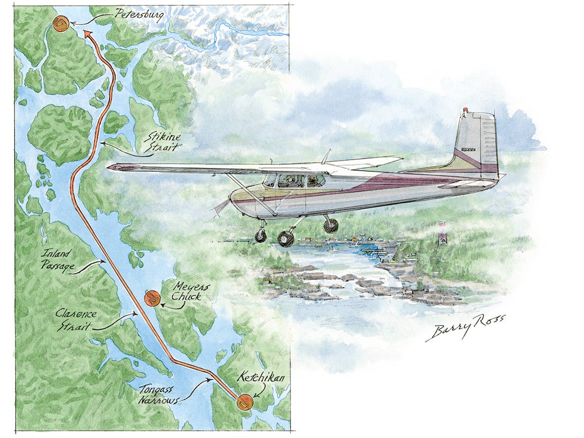
To see more of Barry Ross’ aviation art, go to barryrossart.com.
My best friend, Mike, and I woke to the subtle muttering of raindrops and realized that beyond the curtains of our Ketchikan, Alaska, motel room there was only gray, dismal sky. Damn. At that moment a scenario began that could have ended up as an NTSB accident report, starting with unquantifiable indicators and an irrational discussion.
"Dude. It's raining," I began.
"Ugh," Mike responded. Beyond this legitimate initial transaction the decision-making process began to deteriorate. "What do you think?"
What I should have thought was let's go down to that diner and get some French toast. "I don't know. It looks pretty dismal. Sometimes you can get a better idea from the airport, though. We could go out there at least, call Flight Service, see if it might clear."
"Sounds good."
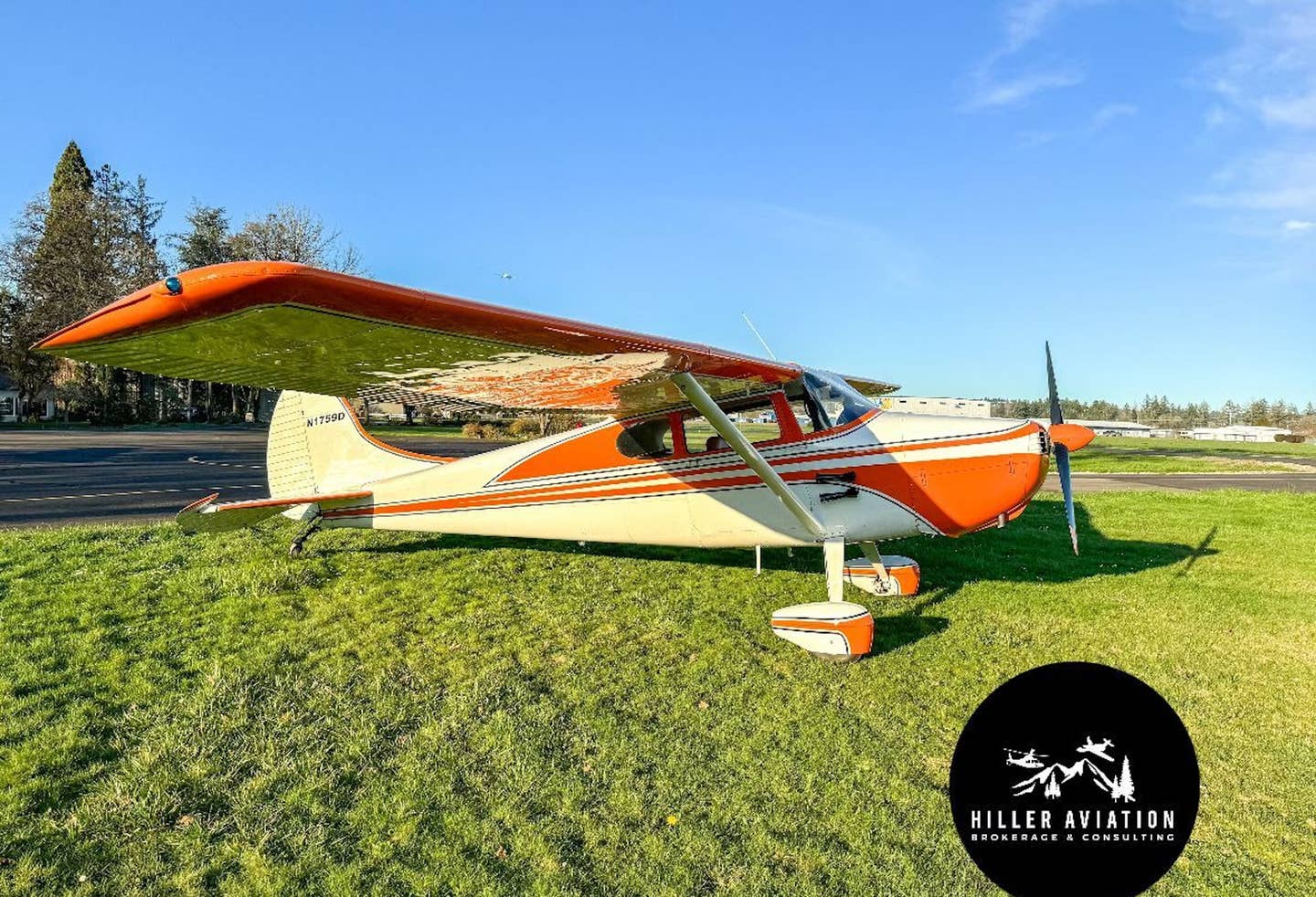
A mental brick existed then. Just one. The kind of brick that eventually forms a barrier to rational thought, beyond which the mind no longer has access. We'd been flying a VFR-only 1956 Cessna 172 with a handheld backpacker's GPS. All of the navigation on our long ferry flight thus far had required plotting the latitude and longitude from the GPS with a draftsman's compass as we relied heavily on pilotage. We should not have taken any precipitation lightly.
It was a two-hour flight up the Inland Passage. The weather report suggested marginal VFR weather, visibility 3 miles in rain, ceilings overcast at 900 feet and something like that for most of the route. Then again, a local pilot enlightened us to the knowledge that the Tongass Narrows draws weather in like a venturi and it gets stuck in the Narrows; if you can get outside of 5 miles or so, often the weather thins. "It might be OK," he had said. Brick two.
As we stood there contemplating, our toes going from damp to numb, a de Havilland Beaver on floats took off from the water and cruised by, leveling off at 100 feet. Looking at each other with a shrug, we traded a silent concurrence that it must be flyable weather.
"We could warm up the plane, get up to the pattern and look at it from there," I suggested optimistically. "Once we get up there, if it doesn't look good out to the horizon, we can just land." More bricks materialized.
"OK, I'll get the fuel sample," Mike replied, never one to put up much of a fight.
We fired up the aging Continental. It was Mike's turn to fly in the left seat. The moisture from our damp clothes and breath condensed on the inside of the cold windows, fogging us in completely until the engine warmed up. Seven minutes passed until the cockpit dried out enough to taxi. We spent that time looking at the sectional and determined we'd be within a four-minute flight of elevations exceeding 4,000 feet at certain points. There would be no climbing our way out of trouble.
We departed Runway 29, and the opportunity to make a weather decision at altitude had its moment. We leveled off, deciding in real time that the only sure way to verify the stranger's claim about the Narrows was to go out there and look. Out where the Beaver had gone ... We reasoned it was safe enough to continue to the northwest as long as we could look back and see Ketchikan, decide from there and then turn around if we weren't comfortable. With that, in an aircraft having no instrument capability and not enough performance to outclimb the terrain, the last brick was mortared into the wall between us and prudent decision making. Ketchikan airport was no longer an option.
Almost immediately the weather worsened, and the only comfortable place to go was down. It became necessary to stay below the very wet-looking clouds, which tended to lurk around under the reported ceiling. We leveled off at 200 feet above the water. For the first time in the flight we made an assessment of the visibility, estimating 2 miles ahead and less than that to the side. We were in the right spot, and the nose was pointing in the right direction. If the visibility stayed like this it was survivable, at least with two people working it.
I plotted a GPS fix and measured a course up the middle of the strait, but after telling Mike the heading, he began turning the plane toward steep terrain.
So I said, "Whoa! Where are you going?"
"I'm flying 320, like you said," he replied, his emotional state rising to meet mine.
"Turn back; turn back to where you were. Fly parallel to the shore for a minute. Is the directional gyro good?" This could get out of hand quickly, I thought.
"Yeah, it's right with the compass. Holding my heading."
"All right," I replied, realizing I had created the problem all on my own. We had flown far enough to the northwest on our trip to be in 21 degrees of magnetic variation, which I had neglected to compute along with 8 degrees of deviation. It was the first notable sign of my performance slipping. The fact that I had made a technical mistake was annoying, in and of itself another stressor.
"All right, I've got it." I figured out quickly if I subtracted 30 degrees from the true answer, Mike would have usable data for the magnetic compass. Thirty degrees. In a conscious moment of contemplation, the first claws of fear constricted my normal thought process. We shouldn't be up here. Fear made the surrounding terrain go vertical when really it was a gradient; it made the visibility conclude when really it was constant; it made solving even simple math equations akin to disarming a bomb with a countdown timer. I increased the frequency of plotting our position to every minute and ran the "true virgins make dull companions" equation continuously, providing Mike a constant source of frantically updated headings.
As we passed Meyers Chuck seaplane base, low and to the right, I saw the cheery-looking yellow and white de Havilland Beaver that had teased us into the sky, moored now against a dock. The pilot had successfully completed what was no more than an errand. A sad epiphany distracted me then — part of why we went is because it went, but we didn't have the same margin of safety its pilots did; we didn't have floats.
I eventually settled into a higher level of economy with the navigational routine, regaining a bit of composure with each accurate calculation. The plotted-fix spacing was narrowing, though, suggesting either we had slowed or a headwind had picked up. Glancing down at the tachometer I read only 1,950 rpm, and I reminded Mike to keep it at 2,100. After he pointed out he hadn't changed anything, I prompted him to check for carburetor ice. The instant he pulled out the carb heat knob a period of violent coughing and sputtering ensued, which at 200 feet over water provided us both a crippling adrenaline rush.
Fortunately the sputtering cleared and the constant hum of smooth rpm returned. Turning off the carb heat brought a 200 rpm increase, which settled back down to the original cruise power setting, and in resolving to check for carb ice every five minutes, we realized the event and ensuing discussion had cost us situational awareness; we no longer had sight of land.
"Dude, I've got nothing but water!" Mike announced.
Frantically scanning the full field of view, I could only concur and suggested we drop down to 100 feet. The circle of visible water expanded, which was enough to help us keep the wings level, but we had no further reference for pilotage. The carb ice event had effectively distracted us into an area with less than 1 mile of visibility.
Bound by the routine of constant, methodical position keeping, we realized a major turn was coming up. We were going to depart the 6-mile-wide Clarence Strait for the 2-mile-wide and curving Stikine Strait. Our circle of visibility had held at less than a mile, and Mike was going to have to make the turn on my command, to a calculated heading that by now we could only hope was accurate. Mike adjusted the directional gyro and checked for carb ice again.
Once the backpacker suggested we were abeam Blashke Island, I decided on a dogleg maneuver and had Mike turn 30 degrees to the right. I shifted temporarily from calculating headings to giving only relative heading recommendations. Using this technique we threaded our way into the strait and faced a series of significant turns to stay in the middle. One GPS fix aimed right at the shoreline, and we found that it was horrifying to look straight down on land.
"Turn left 20 degrees!" I commanded. Mike responded immediately, concurring our only comfort was over water. I checked the backpacker, laid down a course, ran the true virgins and announced the next heading. For a second it looked like we were shooting the gap toward Vank Island, but then the horror of my life presented itself: power lines. Dear God.
My eyes just happened upon the symbol on the map, suggesting in a moment we would have to either duck below or flinch skyward to get over them, but we couldn't see half a mile. It was going to be a last-minute reaction if anything.
"The map says power lines coming up, Dude," I announced. "Scan forward to see which way we're going to go."
"You've got to be kidding me," Mike objected, each of us picturing the massive, high-strung power lines that typically drape great spans.
"Nope, says so on the map. Just get ready to duck."
That may have been the most intense moment of forward concentration for the entire flight, but as our GPS position marched up the strait and past Vank Island on the sectional, we saw nothing more than the circle of water below us and fog ahead. We were certainly past the power lines; as it turns out they were the kind engineered to tunnel below the waterways. We shared a moment of chuckling deflation.
After 45 minutes of intense, almost desperate concentration, the opportunity to laugh at our calamitous predicament allowed us to regroup. We were successfully working the problem no matter how idiotic, and for the first time in the flight, we found resolve.
"OK, stand by for a left turn," I said, convinced nothing could be worse than a surprise obstacle. "We're about to go through the narrowest part."
"Roger, standing by," Mike replied in his best military ready voice.
The next few maneuvers took us right through the second wildlife refuge of the day, and between two points of land less than a mile apart. Mike made each turn with astute and immediate compliance, checking the directional gyro every 10 seconds.
"On my mark there should be visible land within a half-mile out either door. … Mark."
Mike looked left and I looked right, noting only water. Oddly, at that very moment, the drizzle began brightening. Hope suddenly emerged from dread.
"Look," I said, pointing beyond the propeller.
"Yeah, yeah, yeah!" Mike replied, both of us reacting as if we had scratched off a winning lottery ticket. It was clearing.
A few more minutes passed and I realized we would be within 5 miles of Petersburg Johnson Airport. I tuned the CTAF. At once, fate carried us out of whatever weather system we had been in. Visibility improved to 3 miles. We never thought 3 miles of visibility could feel so comfortable.
Off to the left a small airport came into view. We dropped the flaps and landed without further ado, taxied into one of the tiedowns and shut down. We set the parking brake and sat quietly for a minute in the stillness of the cockpit. We'd have at least a day and a night of cold, gloomy camping and energy bars.
We should have chosen the French toast.

Sign-up for newsletters & special offers!
Get the latest FLYING stories & special offers delivered directly to your inbox

