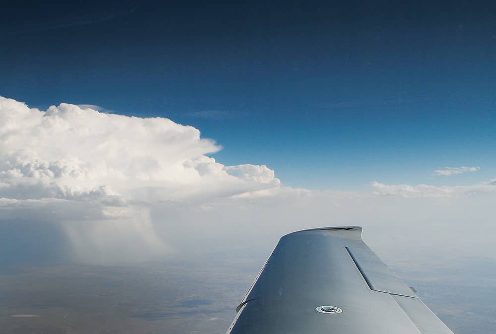
Seeing a mature thunderstorm from this perspective makes it all too clear that torrential rain, strong updrafts and downdrafts, lightning, wind shear and potential hail are all part of the bargain. Which is why it is no bargain. Isabel Goyer
It happens to be my lot in life as a pilot to get to fly regularly a couple of routes that take me through the most active thunderstorm areas in the country. These routes, from central Texas to northern Kansas and, again, from central Texas to Florida, not only point me in the direction of yellow, red and occasionally purple radar returns but also put me in areas of convective activity for long spells. Often a four-hour flight for me will keep me dodging storms for two, three or more of those hours.
My route along the Gulf Coast, traversing a part of the country known as "Dixie Alley," is particularly busy. From around Beaumont, Texas, in the extreme southeast of the state, through southern Louisiana, most of Alabama and through the entire Florida panhandle a couple of hundred miles inland on average, Dixie Alley is home to two to three times as many thunderstorms as the national average elsewhere. As you head east and south, in fact, they get more frequent. Florida has more thunderstorms than any other state, with an average of 90 days per year in which there's a convective storm. The other hot spot, much to my recurring joy, is southern Alabama. Mobile Bay southwest to New Orleans is an extremely active area for thunderstorms, a pocket that rivals Florida in frequency and comes close to the central plains for severity. (Conversely, if you're looking to avoid thunderstorms, fly in the San Francisco Bay Area, where there are only a handful of days a year with thunder and lightning.)
While Dixie Alley is home to more thunderstorms than any other area, those who fly in the central plains would argue that the storms there are more severe. They're right; they are. NOAA has compiled data over a 60-year period on the distribution of severe thunderstorms in the United States, and the heaviest hit region is a 300-mile-wide swath from north Texas throughout all of Oklahoma and all of Kansas. That this grouping coincides with the most active section of what is commonly called "Tornado Alley" should come as no surprise. In order to get a tornado of much magnitude, you need a severe storm (or in the case of Florida, a hurricane or two).
Another big concern is hail, which if severe enough can take an airplane out of the sky. Again, Tornado Alley is home to the worst hail in the country, and Oklahoma is the state with the dubious distinction of being the world's hail capital, with Oklahoma City being right around hailstone center. While thunderstorm frequency is greater in Dixie Alley, storms with 2-inch or greater hail, a measure of the convective power of the storm, are far more likely to occur from north Texas to southern Iowa. Interestingly, the focal point of severe thunderstorms is near Shreveport, Louisiana, 300 miles to the southeast of Oklahoma City.
Knowing the Beast
As you hopefully remember from meteorology for pilots 101, a thunderstorm requires three things to form: moisture, rising unstable air, and some mechanism to get things rolling — this could be terrain or fronts colliding. The rising moist air condenses, forming clouds, with the moisture freezing as it reaches the freezing level. At that point it begins to form freezing particulates, which can be in the form of supercooled liquid droplets (which turn to clear, thick and heavy ice as they adhere to a solid structure, like a wing). The particles are more commonly ice, which depending on the conditions in which it formed, can take different forms, from rime ice to clear ice.
Once a great mystery, the cause of thunder and lightning is better understood than ever. A lightning strike, scientists now believe, is created when ice particles collide with each other over and over again billions of times, giving the smaller particles a positive charge and the larger ones a negative charge. The particles separate and the lightning occurs as the field is discharged. It is not known what triggers that discharge, however. Cosmic rays are one suspect.
As the storm grows it goes through three life stages, developing, mature and dissipating. During the developing stage there might not be much precipitation, making it hard for radar to detect. Even in the developing stage, the rising air can be strong and turbulence severe. As it nears maturity, ice and hail can be present, and a rapidly rising storm can climb at a couple of thousand feet per minute or more in extreme cases, so outclimbing a fast-developing storm in a light plane is folly.
As the storm matures, it is potentially even more deadly. A steady-state storm can stay in the mature state for hours, taking in energy from behind and releasing downdrafts and gusts in its direction of movement, all with severe to extreme downdrafts, wind shear and turbulence.
Thunderstorms can form at any time, in any season, and in any place, but there are hot spots and risky times that every pilot should know about. Tornado Alley and Dixie Alley are well-known hot spots, and the times of year you're likely to find severe storms are from April through September.
Low-Altitude Hazards
During this mature stage, one of the most deadly features is the microburst, a hard-to-predict localized and short-lived phenomenon that is characterized by severe wind shear and downdrafts. Wet microbursts are accompanied by heavy rain, blinding to pilots attempting to fly through it, though dry microbursts, which are more difficult to spot, can have little to no precipitation but can wreak havoc on a flight departing or arriving at an airport in the immediate vicinity of the storm.
Microbursts are a leading cause of accidents in both airliners and light airplanes. In 1985 a Delta Airlines Lockheed L-1011 TriStar, Flight 191, crashed after encountering a microburst on approach to Dallas-Fort Worth International Airport, killing 137 passengers and crew, including a motorist on a highway the jet skidded on after crashing a mile from the threshold of Runway 17L. The airliner was equipped with cockpit voice and data recorders, and the narrative of the final moments of the flight are horrifying. Sadly, such stories are all too predictable when it comes to microburst encounters.
After it flew into stormy weather on final approach the flight encountered severe wind shear, with an increase in airspeed of greater than 25 knots to 173 knots (much higher than the plane's maximum landing speed) and a sudden reversal of that airspeed to 133 knots. Despite valiant attempts to arrest the uncommanded descent, the crew was unable to prevent the jet from hitting the ground at a rate of descent that momentarily registered 5,000 fpm despite the application of power. The crew was faced with a situation — rapidly decreasing airspeed accompanied by downdrafts — that despite their best efforts they were powerless to overcome. To avoid a stall the pilot flying did exactly what he should have — lowered the nose and added power — but since the jet was in a severe downdraft at the time, there wasn't enough altitude to save the day. The entire flight crew perished in the crash.
The only way to avoid the threat of microbursts is to avoid storm cells on approach. After the DFW disaster in 1985, a similar disaster at Charlotte-Douglas International Airport in North Carolina in 1994 and another in Little Rock in 1999, controllers and pilots are more aware of the dangers of microbursts than before, but these accidents keep happening, which makes me believe that an abundance of caution is in order whenever approaching (or departing) in the vicinity of thunderstorms.
Another big risk with thunderstorms is turbulence so severe that it can break an airplane. There are numerous cases of this happening, from the crash that claimed the life of legendary test pilot Scott Crossfield after he flew into an area of severe thunderstorms, to the in-flight breakup of a Pilatus PC-12 in central Florida after its pilot lost control maneuvering to avoid similar severe storms. Sadly, the list of such losses could go on for some time.
The loss of an airplane in a severe storm can be due to one or more of several factors, extreme turbulence, severe icing, hail, rarely but sometimes lightning, or loss of situational awareness leading to overstressing the airframe. Pilots unfortunate enough to be caught in a severe storm would do well to accept whatever altitude the storm gives them and keep the wings level. Initiating a turn to get out of the storm you just entered might make sense ... though the turn itself introduces a new layer of risk.
The short and easy answer is this: Just don't get into the storm to begin with. Keep your distance from big cells. How far is that? Opinions vary, but I stay 20 miles away at the least. Farther is better.
So, how do you avoid wandering unintentionally into an active cell? First and foremost, you need to know where thunderstorms are ... and where they might be. The first line of information is an in-cockpit weather device. If you're a pilot who flies for transportation, there's no excuse not to have one, whether it be a panel-mounted SiriusXM receiver or an ADS-B-In device or a tablet-enabled ADS-B weather receiver.
Bad Nexrad?
After a couple of accidents in which pilots are suspected to have flown into severe storms that hadn't yet shown up on their in-cockpit weather devices, there was a widespread reaction from regulators and pilots alike that somehow Nexrad was to blame for the accidents. It wasn't, and the suggestion that Nexrad in the cockpit, along with the other useful weather products it comes packaged with, somehow adds to the risk is the kind of bad advice pilots get all too often. That is, if information can lead us astray, then we should discard all of it, instead of using it wisely.
As with most tools, there is a built-in risk with satellite weather. Between the time the Nexrad antenna sweeps and detects a storm to the time that image gets to your display (whether via satellite or ADS-B ground station), 15 minutes or more might have elapsed, so that information might not be accurate any longer. The takeaway here is both easy and nothing new: Don't use satellite or ADS-B weather tactically, that is, to dodge storms on the go. The problem is that you might be in the murk, heading for a clear spot on the display, when actually that empty space has filled in over the past 10 minutes or so with a rapidly developing cell.
Pilots can avoid this trap if they stay visual whenever possible in order to see the storms that weren't there a few minutes ago, or better, to see that there aren't any. Also, if you have onboard radar, learn to use it. If you don't, or even if you do, ask for help. A controller's radar display, though not as informative as a satellite Nexrad feed, is a lot more recent than the display on your iPad, along with just being a second or third vote on the matter.
It's also important to have an out, and that out is for most airplanes not above the storm but in the other direction. Use radar strategically to see what flight path is most likely to give the best clearance from storms. If you're dodging isolated cells, this is not particularly hard to do. When you're trying to find gaps in otherwise solid lines of convective weather, it can be much trickier. How much rain is present based on the color of the return? Is dark green safe to fly through? Is an isolated yellow stretch passable, perhaps with only moderate turbulence and rain? Have other airplanes flown the same routing? If so, how recently have they traversed it? At what stage is the storm? Is it developing, mature or dissipating? If you're in the clear and can see the weather with the naked eye, then many of these calls are far easier. Just be careful that you don't fly through one section of passable weather only to find yourself facing a section of severe weather.
Knowing what's happening behind you is paramount, because nine times out of 10 that's where there's safe harbor. So it's critical to have a very clear picture of the ceilings, the visibility and the chances of storms or fog forming behind you. It's rare for a pilot to get trapped in adverse weather after turning around to avoid a storm, but it can happen. If the road forward looks dicey, make certain the road back is clear.
Which leads to another critical step, making diversions a part of the plan. When you're negotiating large areas of convective weather in a small airplane, there's a good chance that where you intend to land (for fuel or for the night) is not where you're going to wind up. Work the act of choosing an alternate airport into the very fabric of your flight when storms are playing havoc with your routing. On a 500-mile trip there are literally hundreds of available alternates. With great apps a couple of touches away on your favorite tablet and with panel-mount equipment with great information in many airplanes, there's nothing but data within arm's reach. Get it. Know it. Commit to making a change before it's an emergency, before it's even tense. It's easy and you'll probably get to know a cool new airport.
Thunderstorms present one of the greatest dangers to light airplanes, which have neither the climbing ability nor the ceiling to surmount most storms (which is not a good strategy to begin with). Because most small planes lack ice protection, there's that additional hazard to contend with, though icing in thunderstorms can be so severe that even ice-protected airplanes are at risk.
Few pilots fail to understand the severity of the risk, but it can be all too easy to fall into the trap of getting lucky and finding your way through a few storms despite taking risks on the way. The message here is simple. Take a reality check. Instead of accepting those risks, commit to minimizing them every step of the way on every trip. When you're no longer assured of safe passage, simply turn around and land somewhere safe. Wait it out and fly on the backside of the storm. Most likely you'll get clear skies and headwinds and won't mind much at all.
Avoiding Storms? Good Luck.
The bad news we all have to face at some point is that, if you fly for transportation, you're going to have to deal with thunderstorms. Just accept it. Trips early in the day are typically convection free (yay), but if you're like me, you probably make a lot of trips back home in the late afternoon or early evening, when storm activity is typically at its peak. Acceptance, planning and patience are key traits for this kind of flying. Don't skimp on the preflight weather briefing. Take an extra-long look at the radar, the prognostic charts and the forecasts for the area and for airports along the way. Visualize the route, and plan your diversions early while always being ready to change those plans too. And if you don't have weather in the cockpit, get it. Having timely weather information at your fingertips is arguably the best safety tool that pilots of GA planes have ever had. Get it and use it.
We welcome your comments on flyingmag.com. In order to maintain a respectful environment, we ask that all comments be on-topic, respectful and spam-free. All comments made here are public and may be republished by Flying.

Sign-up for newsletters & special offers!
Get the latest FLYING stories & special offers delivered directly to your inbox

